
Montoursville firm flying high with new technology
Trending
A company is soaring to ever-higher heights with new technology for its clients in need of surveying and mapping.
McTish, Kunkel and Associates, Montoursville recently began using a single unmanned aerial vehicle (UAV) to provide accurate and faster services.
"It is to better serve our clients," said Timothy Milholin, survey projects coordinator.
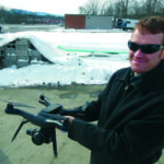
Milholin and Barrett Allison, survey manager, recently demonstrated how the UAV works.
Small enough to hold in Milholin's hands, it rises to heights as high as 400 feet to take high resolution photographs over an area for surveying and mapping purposes.
"We have seven people in our Montoursville office licensed to fly it," he said.
Milholin calls up an APP on a tablet to control the operations of the UAV.
"It does a checklist," Allison said.
In as little as four minutes, the UAV can take up to 64 photos.
A key component of the unmanned aerial system technology is in its capturing of images to measure distances between objects.
"It stitches all the photos together to get one photo," Barrett said. "It's how you get contour maps."
Allison said the rotorcraft, sometimes referred to as a drone, has certainly cut down on the amount of time otherwise spent to do their work.
Among the company's clients are municipalities, oil and gas companies and other private enterprises.
The technology also can be an inexpensive alternative.
Surveys often are used for mining operations, landfills, site developments, environmental inspections and security services.
While certainly a benefit for surveying and mapping, the UAV has its limitations, such as obstructions along terrain it photographs.
"I think the technology is only going to get better," Allison said.
The company has been using the new technology, which is regulated by the Federal Aviation Administration, since December.
"This is another tool in the toolbox," Allison said.