
City of Williamsport officials to preserve historic map collection
Trending
Williamsport City Hall, condemned since 2021, has a treasure trove of historic maps that city officials want to see preserved.
"The city was fortunate to receive grant funding from First Community Foundation Partnership of Pennsylvania for the first phase of our digitization project," said Valerie Fessler, executive director of the city Department of Community and Economic Development.
It is a $125,000 grant and the first phase prioritizes financial and other letter-sized documents, Fessler said.
The digitization of historical maps and other larger documents will be part of a second phase of this records digitization project, Fessler said.
Preserving this map history is important to Mayor Derek Slaughter.
He recently told council that there is a plan and legal procedure in place to keep the maps safe from damage after the subject of what would happen to the maps was brought up by resident Bruce Huffman.
All records will be maintained and cared for in storage, specifically with maps being moved to the Reighard Avenue Bureau of Codes facility, Fessler said, echoing what Slaughter told council.
The maps include those depicting the community's earliest years when it was a borough before the city charter was signed in 1866.
City Hall construction began in 1888 and continued into the 1890s. Workers found old survey maps in the building.
These historical maps date back to the late 1800s. They show old street layouts and property lines from the city's past.
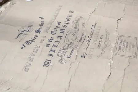
For example, engineers in the former city administration found a city survey map drawn by John B. Otto on Aug. 1, 1876.
Many of these are preserved by online university libraries, such as the Penn State University Libraries' Digital Collections.