Geologist explains local formations that roused spiritual curiosity of early settlers
The Lycoming Valley’s first historians tell us the area bore a kind of spiritual significance to the Native Americans who inhabited it before them. Peculiar and unexplained geologic formations may have contributed to the mysterious sentiments, but these outcroppings have scientific explanations, according to a local geologist.
A Moravian missionary and German Protestant reformer, Count Nicolaus Zinzendorf, traveled through the valley in the 1740s and journalled about his visits.
“The surrounding country and the West Branch of the Susquehanna are called the Otzinachson, i.e., the ‘Demon’s Den,’ for here the evil spirits, say the Indians, have their seats and hold their revels,” he said.
In a 1967 article printed in the Williamsport Sun-Gazette “Spooky names abound,” the writer said John F. Meginness, 18th century Lycoming County historian, attributed many of the area’s names involving deadman, devil or demon, to the rumors after the Native American attribution.
Northern Pennsylvania can attribute much of its rolling mountains and valleys to glaciers which have covered the continent in thousands of feet of ice several times in the course of earth’s history. Many large rocks now found in Pennsylvania can be traced to Canada, according to the state Department of Conservation and Natural Resources.
The most recent glaciation period, for example, which covered a large amount of Lycoming County, called the Wisconsinan, is associated with three advances and recessions between 22,000 and 17,000 years ago, according to “Pennsylvania and the Ice Age.”
The Devil’s Turnip Patch, a boulder field south of the Bald Eagle Mountain overlook on Route 15, is a derivative of this process that’s caused locals to scratch their heads, according to Veronica Ciavarella, professor of Geology and Environmental Science at Pennsylvania College of Technology.
“It’s quartz-rich sandstone called the Tuscarora Formation. Boulders were broken away from where the Tuscarora is in place further up the ridge and deposited by retreating glaciers during the last ice age,” she said. “Iron oxide staining of the rocks gives them a pink to purple coloration, making it appear as a ‘bad’ turnip patch, presumably leading to the name Devil’s turnip patch.”
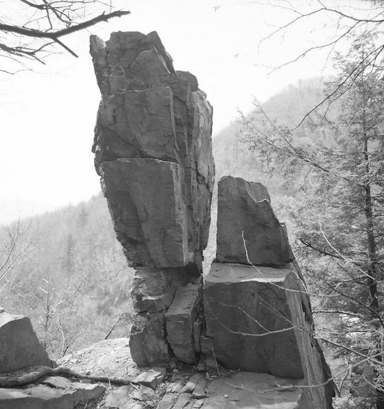
Another odd formation, the Devil’s chimney, located along Mosquito Valley Road, south of DuBoistown, is a 12-foot-tall outcropping that seems to have risen up from the earth.
However, Ciavarella said it’s more likely weathering that’s torn down surrounding rock at the joints, which have been formed from a mountain building process similar to the Appalachians.
Scientists are largely in agreement that the Appalachians were thrusted skyward during a tectonic plate collision somewhere around 480 million years ago, according to the United States Geological Survey. As one plate moves under another, the sinking plate was super-heated. The rising of material pushed the Appalachian mountains up.
“What’s probably happened with (Devil’s Chimney) is a result of weathering along with natural planes of weakness in the rock causing it to break apart in this kind of block-like shape.” said Ciavarella. “The weaknesses are due to joints and the bedding planes. Joints are just natural fractures in the rock that form due to mountain-building events.”
Over thousands of iterations, water moved it’s way into the chimney, froze and cracked it at its weakest points, said Ciavarella. The joints tend to be nearly perpendicular to each other in our area, and so the rocks often break apart in rectangular blocks.
“It probably just so happened that the rock surrounding this one was broken off and fell away, and left behind this very neat-shaped outcrop,” she said.
Top News
Lycoming County sheriff’s department offering two online services
County residents will now be able to apply for a license to carry (LTC) permit online following approval by the ...
City of Williamsport police to hold parents, guardians accountable for juvenile crimes
Williamsport Bureau of Police claim they will be holding parents and guardians accountable for certain illegal ...
Williamsport Parking Authority submits proposal to increase parking fines

Montoursville woman to appear on Jeopardy tonight

Lawmaker’s resolution honors contributions of Negro Leagues
Doctor offers his take on solar, chicken farm as a Muncy resident
Family physician Dr. Steven Barrows, admittedly, is not against poultry farms. Barrows, of Muncy, shared how he ...