New look, old view: Engineer unearths old maps in City Hall
Engineer unearths old maps in City Hall
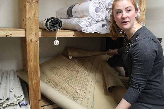
KAREN VIBERT-KENNEDY/Sun-Gazette Rebecca Haladay, city engineer and assistant manager of the public works department, inspects a map room in the basement of City Hall, where she discovered many maps that she said can assist her in daily engineering projects this year and beyond.
KAREN VIBERT-KENNEDY/Sun-Gazette
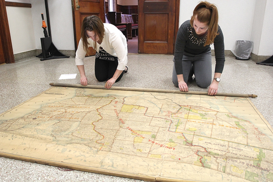
A 19th century map of the United States, which contains entries such as the Louisiana Purchase from France, is inspected in the foyer of the second floor outside of City Council chambers by city employees. At left, Chelsea Myers, city planner, looks over most of the western U.S. while Rebecca Haladay, city engineer and assistant general manager of the public works department, inspects the eastern U.S., which still was listed as “colonies” on the map she found in the office of former engineer John Grado.
KAREN VIBERT-KENNEDY/Sun-Gazette
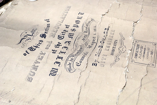
A document reveals a survey of Williamsport done by John B. Otto, survey engineer, on Aug. 1, 1876. The document is among many recently discovered in City Hall by Rebecca Haladay, city engineer and assistant general manager of the city public works department.
KAREN VIBERT-KENNEDY/Sun-Gazette
Rebecca Haladay, city engineer and assistant manager of the public works department, inspects a map room in the basement of City Hall, where she discovered many maps that she said can assist her in daily engineering projects this year and beyond.
(EDITOR’S NOTE: Today the Sun-Gazette offers the next installment in a weekly history series that tells the stories of those who came before us.)
Sometimes history smacks into the present day.
For Rebecca Haladay, city engineer and assistant general manager of the city public works department, a discovery of a treasure trove of maps and a digest by Lyons Mussina, a city engineer who remarks about works during the Great Depression in the 1930s, was not only interesting but useful.
She recently showed off the digest and an 1887 map she found in the office of John Grado, retired city engineer. Haladay was moved to the city public works building during the transition and was cleaning out the room now occupied by the city controller and deputy controller when she found the items.
The digest contained several handwritten and typed pages. The map was crafted 21 years after Williamsport’s charter in 1866.
It showed how relatively tiny the community still was, with expansion not seen going west of Grier Street, although the sections of Jaysburg and Newberry were established.
Haladay also found maps in the basement of City Hall in a room used as storage for the codes and engineering departments. A few of the topographical maps found inside had pencil markings on them and were composed of a combination of linen backing and paper. They were worn, had a dark brownish color and were in a delicate condition.
Haladay said the 1887 map and some of the historical references by Mussina will help her as she researches the fourth phase of the city’s Pathways to Health.
The multi-year project — to improve a specific corridor from Interstate 180, up Maynard Street, east on West Third Street, north on Campbell Street and east on Little League Boulevard to Walnut Street and the entrance to UPMC Susquehanna– has had three phases completed.
It is along this path that the Pennsylvania Railroad line once stopped at a station behind the Peter Herdic Hotel, now called Park Place.
John F. Meginness, author of the 1892 “History of Lycoming County,” confirms the popularity of the railroad stop and how Herdic’s grand hotel became a destination for visitors.
Today, the site of the station, known as the Peter Herdic Transportation Museum, beckons to visitors at 810 Nichols Place.
The map shows the precise location of the railroad and the former Round House building that turned the trains around in different directions.
“The city purchased the land along Little League Boulevard from Conrail,” according to Mussina’s musings in his digest.
Before the boulevard, the railroad track right-of-way existed, even though the rail line was abandoned, according to Grado.
Haladay said it would be nice to incorporate some of the railroad history into the pathway design.
As the city works with the Williamsport Municipal Sanitary Authority on designing stormwater management systems, the map becomes an important tool.
When Haladay perused more of the digest, she discovered how much of a flooding problem was caused by old Grafius Run in the 19th century.
“I think it’s good to have a history, especially of Grafius Run and old Grafius Run,” Haladay said.
One map clearly showed her that the direction of old Grafius Run took a turn at the site where the former Mater Dolorosa Church stood on Hepburn Street near Park Avenue, before the run was enclosed.
From there, old Grafius Run went east through Lycoming College and ended up crossing the Central Treatment Plant area.
It flows there still but does not carry as much water because it doesn’t drain as much as it did before, Grado said.
The map also shows the old and new channels of Grafius Run, particularly where the old channel once flowed east into the area of Lycoming College and dumped into the river near Railway Street, according to Haladay.
“It’s important to know where the older run goes for the inventory of the city storm sewer system,” Halady said.
Other interesting entries in Mussina’s digest also are relevant to today’s engineering work.
Included in his digest is the completion of the former Market Street Bridge on July 5, 1849.
The bridge was built by the Williamsport Bridge Co. at a cost of $23,797, but not long afterward was carried away in a flood on March 17, 1865, Mussina wrote. Construction of a wire suspension bridge started that August and was finished in December, at a cost of $58,068, and later the Maynard Street bridge was built in 1876.
Haladay said it’s important to know the original history of these spans across the West Branch of the Susquehanna River, and Mussina’s writings are helping provide that knowledge.
Haladay also unrolled a third map. It was drawn in 1900 and showed the United States, carved into land masses, including the “Louisiana Purchase from France,” and Gadsden Purchase in lower Arizona and New Mexico. It marked the original 13 colonies.
The map, while not as relevant as the 1887 one, is considered a keeper by Haladay.
“I love history and found this fascinating,” Haladay said.
Top News

Pine Creek Township to consider ordinance amendment to address data centers
East Lycoming School District names interim district leadership
During a recent work session, the East Lycoming School District board appointed Gerald McLaughlin as interim ...
City of Williamsport, STEP Inc. partner on property rehabilitation
Elderly man’s body pulled from pond in Muncy
MUNCY — The Lycoming County Coroner’s Office and state police are investigating the death of an elderly man ...
Rose Valley Lake drawdown tentatively slated for Fall 2027 for dam rehabilitation
Lycoming County sheriff’s department offering two online services
County residents will now be able to apply for a license to carry (LTC) permit online following approval by the ...